 USA
USA United Kingdom
 Germany
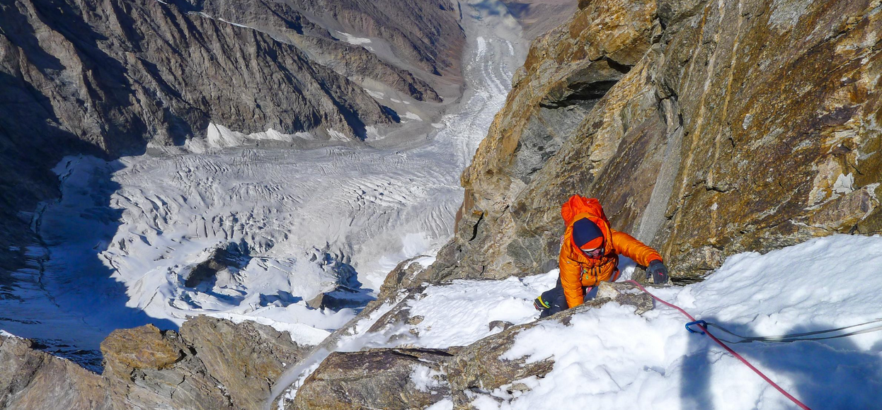
The Great Game | Koyo Zom

In Autumn 2019 Tom Livingstone along with Uisdean Hawthorn, John Crook, Will Sim and Ally Swinton headed to Pakistan to attempt un-climbed lines on the north side of Koyo Zom. Ultimately Uisdean, John and Will spent several days trying a new line tackling the north-east ridge but had to turn back due to poor snow conditions and deteriorating health. Tom and Ally took a different line, on the north-west face, and summited after 5 days on the route.
Words by Tom Livingstone
Images by Tom Livingstone, Ally Swinton and Uisdean Hawthorn
Due to political instability and tension, the Hindu Raj region had quietly slipped off the radar but Will Sim had recently ‘re-discovered’ this mountainous and remote region in the north of Pakistan. Bordering Afghanistan, the Hindu Raj is an extension of the Karakoram range (itself an extension of the Himalayas). Until only eight years ago, the Taliban had occupied the nearby Swat valley.
Will’s research found an area with plenty of alpine potential, and one mountain stood out in particular: Koyo Zom, at 6877 metres. Will sent a few photos of this impressive peak, with a huge north-west face, to John Crook, Uisdean Hawthorn, Ally Swinton and myself. We all accepted the invitation, and travelled to Pakistan this September.
Koyo Zom stands like a Mogul fortress in the wilds of Asia, its bulk looking towards the plains of Afghanistan, Tajikistan and China. The north face itself is threatened by enormous seracs, so you can see why the mountain has only ever been climbed from the eastern side: in 1968, by an Austrian team, and in 1974, by Brits.
Our Trip

Photo by Uisdean Hawthorn
Our team of five was joined by four Pakistanis, who organised logistics, cooked delicious meals, and helped with everyday life in Base Camp. Arriving in the Yarkhun valley on our sixth day in Pakistan, and finally seeing the enormous Koyo Zom, we set up our tents on the grass outside some shepherd’s huts. The locals were initially shy, but soon we were playing games and trying to explain that we’d arrived in their front garden to climb the mountain in the background. They just shook their heads and ‘tutted!’
Acclimatising - perhaps the least enjoyable part of an expedition - involves spending many days lying in a tent, with a slight headache. Any effort to exercise or be creative results in bending double, breathing deeply, and a heartbeat which thumps out of your chest. Thankfully, it was at least sociable as a team of five, and we bantered back and forth in our two tents.

Photo by Uisdean Hawthorn
Finally, after three weeks of settled weather and two acclimatisation trips, we were all (mostly) ready to climb. Unfortunately, Will and Uisdean had been ill and missed the final acclimatisation trip, so together with John, they decided to attempt the left-hand skyline of Koyo Zom (the north-east ridge). This looked slightly more amenable and would give them more time to acclimatise.
Ally and I were psyched for the right-hand line (the north-west face). It was our original inspiration for coming on this trip, and it looked incredible. An icefield rose into an enormous headwall, with (hopefully solid) golden granite of rocky buttresses. Ally and I also thought the line looked hard, and we expected a fight - or to be unsuccessful.
Packing takes as long as you’ve got. All five of us spent the day micro-debating and analysing what to take, based on what we guessed about the climbing. Ally and I clutched pieces of paper with lists and scribbles, afraid of forgetting something crucial. Finally we had two rucksacks ready, looking like giant snail-shells. Our bags were super heavy (around 16kgs), but we considered everything to be essential: a double rack of cams, set-and-a-half of wires, ice screws, set of pegs, quickdraws, two micro traxions, single 9mm rope and tag line, headtorch with one spare battery each, technical axes and crampons, a pair of rock shoes, helmets, stove, double sleeping bag, single-skin tent, clothes, boots and roll mats.
The new route (The Great Game)

Will, Uisdean and John launched for the left-hand line, whilst Ally and I for the right. We spent the first day climbing the lower icefield, reaching a bivy as the afternoon sun spilled onto the face. We’d previously bivied here in order to acclimatise, so we were grateful of a pre-chopped ledge for our snow hammock. This earlier acclimatisation trip was also useful to learn how cold it was, and what clothes to wear.
The following day, Ally led up mixed chimneys, hauling the bags on a tagline. They seemed to catch on everything, and scrape up the sharp granite. I took over and led us up frozen-in flakes and spikes of rock, like being in a climbing wall. After a steep tongue of bullet-hard ice, we reached a snow ridge, where we could pitch our small tent. It felt deserving of the Greater Ranges, with amazing views as the sun melted into the horizon.

The next day we reached the most impressive and intimidating feature of our route: a 90-metre headwall of overhanging and vertical rock, which looked like it would shut us down. I was a little doubtful if it’d go, and we hung on a creaking belay and craned our necks upwards. We spied a weakness of more featured rock, which looked to give us a subtle passage through the steep ground. I gingerly aided up a crack, mixing free and aid moves, to belay under big roofs. It felt just like Gogarth’s Main Cliff, a place I’m very fond of - but much more wild, considering it was at 6200 metres!
I pulled on my rock shoes and delighted in tip-toeing through the steepness; the rocks I threw over my shoulder fell for hundreds of metres, and the sunshine made it briefly bearable to climb in bare hands. Rock shoes were much better than double boots and crampons!

Ally and I enjoyed another long, cold night in our double bivy bag, sitting on a sofa-ledge created by our snow hamomck. The following day, we climbed a loose pitch to pop out of the headwall, and then followed easier ground to gain height quickly. We suffered from the altitude, checking into our ‘altitude pain-caves’ and crashing out for another bivy.
Finally, on the fifth day, we slogged to the summit and whooped at the amazing views. Although we figured Uisdean, Will and John had turned around since we couldn’t see their tracks, Ally and I were still super psyched to have climbed a new route, which looked so unlikely and tested us just enough. We descended to the Pechus glacier that afternoon, crashing out as dusk settled.

Rescue
The next day saw us walking down the Pechus glacier, with hungry stomachs and tired bodies, but we were pleased all the technical climbing was finished. We were roped up and weaving through crevasses when Ally fell about 15 or 20 metres into a crevasse. I was able to hold the fall and then pull him out using a 3:1 pulley system.
Unfortunately, Ally sustained a head injury and bruising to his arm and leg. He couldn’t really walk and the head injury was bleeding quite a lot. I gave him first aid and helped him as best I could, and pressed the SOS button on our Garmin InReach Mini.
The helicopter couldn’t reach us on the first day, and in the evening Ally’s condition deteriorated. I was quite concerned he might die in the night. Thankfully, we made it through and we were rescued in the afternoon on the second day. It was a strange juxtaposition: to have climbed one of the coolest, luckiest alpine routes I’ve ever done, as a first ascent in Pakistan… and then be rescued and in hospital with Ally getting his head stitched up. Ally suggested we called the route, ‘The Great Game.’ It seemed fitting.

The main thing is that we’re all back safely. This experience has certainly put things in perspective. On reflection, overall it was a brilliant trip with good friends, to a wild area, and with very friendly locals. I’m very proud of the new route Ally and I climbed, and psyched for more.